Discovering the underground path of Orte, the ancient Etruscan city on the Tiber river
Orte lays on the top of a tuff spur with its particular “ham-shaped” layout. Probably founded by the Volsinii as a military outpost at the confluence of two rivers: the Tiber and the Nera, it became Etruscan, then Roman from 299 BC, and became a Municipium in the Augustan age thanks to its strategic position. The ancient port of Seripola, on the Tiber (that was something like an highway to Rome) allowed to send to Rome the artifacts made from the numerous brick factories and sealed terracotta found in the area. Strategic for communications and commerce was the so-called bridge of Augustus, which crossed the Tiber allowing the via Amerina, which from Falerii Novi passed through Vasanello and Orte, to reach the capital of the Empire.
During the barbarian invasions, Orte resisted and remained the last Byzantine outpost, for this reason it is rewarded with the strengthening of its defenses and elevation to the Diocese. Throughout the Middle Ages the city enjoyed a period of prosperity thanks to trade and the passage of pilgrims bound for Rome. In 1515 the bridge over the river collapsed, with it the importance of Orte. In the nineteenth century it regained its role thanks to the advent of the railway, Orte is an important Italian railway hub.
Under the floor of Piazza della Libertà, at the foot of the stairs of the Cathedral, it is possible to see at a glance, as if looking at a hypothetical window on the past, the rests of various eras of Orte’s life: from the flooring of the forum, to a late medieval burial ground.
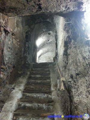
On the floor of the square a staircase opens: it is the access to Orte Underground path and to an underground fountain, that was, for a long time, the only source of supply for the citizens, as evidenced by the stones consumed by the women who came here to fill their jugs. Here the entrance to the main tunnel, discovered in 2008.
The network of tunnels that made up the hydraulic system of the city reveals the different phases of the life of the town and its construction. Passing from the Etruscan phase, with very narrow transverse tunnels for the collection of rainwater that filtered from the tuff rock and which was conveyed in small cisterns, to the Roman phase, during which the growth of the city, elevated to Municipality, made further works necessary for the supply of water.
A large tunnel is then excavated, through which water is taken from a source and conducted to a series of cisterns of which the main cistern is the current underground fountain.
This hydraulic network visible in the path of the Orte Undergound is also implemented by secondary tunnels in order not to waste excess water that was conveyed into additional tanks. Some steps lead to the bottom of a cistern placed under a medieval noble palace with a large opening. The presence of the steps and a convenient access tunnel are the evidence of the reuse of these rooms over the centuries: the cistern became part of a cellar used for the storage of the barrels.
Newer tunnels cut other older ones once they have become useless, and every now and then, looking up, it is possible to notice “cappuccina” roofs for the reinforcement of the vaults, or the “pedarole”, the grooves on the walls that allowed an agile descent along the walls of the wells and cisterns.
Occasionally small openings make visible cisterns now closed by overlying and inaccessible buildings, we pass through a maze of overflow tunnels, cisterns, cellars of a medieval tower-house of which you can also see the access stairs, until to reach a well from Roman times whose opening falls in the center of a circular room, plastered with earthenware. Very interesting are the residues of a particular clay used for waterproofing the environment and even more another opening, added in medieval times, probably replacing the previous opening, once it became unusable.
The current path of Orte Underground ends with a room used for the processing of wine, the grape pressing tank and the grooves where the must flowed are visible.
Emerging from the Orte Underground and returning to the sunlight, narrow and suggestive alleys act as a curtain with sudden openings towards the green landscape and the opposite hill: the hill of San Bernardino where the Etruscan necropolis is located.
In San Sebastiano district, under the hospital of Orte, tunnels, hospital wash-houses, cellars and, at the bottom of a staircase, the snow well of 1891, always made for hospital use are visible. The snow of the Cimini Mountains was brought overnight and stored in the well in order to store medicines. The adjacent room, where we are located,thnks to the temperature, was used as a mortuary…
Close to the cliff, from where you can enjoy a wonderful panorama of the Tiber and what remains of the Ponte di Augusto, the access to the medieval dovecotes, open spaces to the outside where the pigeons were bred, housed in a dense series of small hollows of which the walls are dotted. Also in this case, once abandoned in the 14th century, these rooms are used as cellars.
The small Orte amazes for the charm of its maze of narrow streets, a town which is urbanistically well preserved, waiting to be discovered, with an atmosphere that seems to be suspended over time.
Benedetta Tintillini
Find Orte Underground on Google Maps: